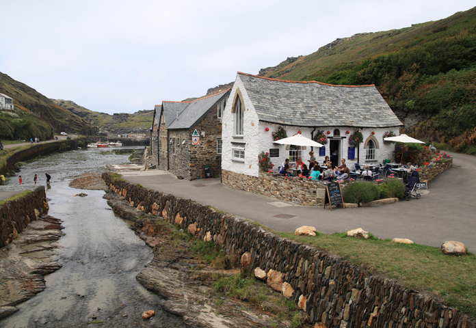

In 2004 a catastrophic flood tore through the village destroying 5 buildings and damaging 47 others. Remarkably no life was lost. Following this disaster the challenge was to reshape and enhance Lower Boscastle’s flood protection, creating a safe environment that maintained the community’s sense of place and identity.
Nicholas Pearson Associates (NPA) was appointed as landscape architects to the project team to work with Halcrow Group Ltd to deliver a flood alleviation strategy in a way that was responsive to this sensitive and heavily protected landscape. A full Environmental Impact Assessment was undertaken with NPA providing concept design inputs, consideration of high level design alternatives and preparing a Landscape and Visual Impact Assessment of the preferred solution. The project team worked within a challenging brief defined jointly by the Environment Agency, North Cornwall District Council, the National Trust and the local community.
The design process consisted of three main steps:
1) Identification of the distinctive characteristics of Lower Boscastle: the village can be divided broadly into three character areas. Landscape strategies were devised for each character area. Achieving flood alleviation, landscape conservation and landscape enhancement together was the overarching priority.
2) Assessment of the flood damage on ‘micro’ scale landscape elements: the condition and value of physical elements that remained post flood were assessed in order to understand the damage caused and what items retained historical integrity. This phase drew upon earlier character studies, photographic evidence, discussions with local people and historic map studies. The assessment showed for example that the constrained river channel had been wider in places during the eighteenth century, and over time the channel had been in filled and riverside land had been built on to allow port activities to expand. The scheme allowed for the restoration of some lengths of bank to their earlier positions.
3) To review and tailor the engineering design options to the location: A significant element of the process was to define how much change could be tolerated by the protected landscape. This understanding of acceptable change influenced the development of design options. The most significant design interventions were directed towards those parts of the environment that had the greatest capacity to accommodate change or which would benefit most from enhancement whilst coping with flood flow predictions.
All proposals were evaluated in terms of their potential for beneficially influencing the overall sense of place in order to protect the historic integrity of the village.
The widening and deepening of the river channel, a key element in increasing the capacity of the river to handle flood flows was facilitated through the preparation of a river walling design guide that identified and retained surviving, authentic stone walls, defined vernacular wall styles and walling techniques to be used. It also guided the selection of appropriate materials, stone sizes and colours to avoid any possibility of losing the key sense of detail, variety and authenticity.
The main car park access was improved and the parking area was moved away from the river edge incorporating the design of over land flow routes and vehicle escape routes, reducing the risk of flooding and improving the riverside environment. This improved river habitat and increased biodiversity potential through the use of native planting, meadow restoration and hedge replacement has been established on reinforced embankments beside new riverside footpaths.
The final element of the project was to reconnect the east and west banks by the harbour with a new foot and vehicle bridge to replace the one washed away by the flood. Considering the potential future flood flows, the picturesque protected setting and significant stakeholder influence, a number of options were developed and tested through the preparation of photomontages. The favoured bridge design, now complete, appears on post cards of Boscastle and has been recognised for the quality of its design.
Overview
-
Project Name
Boscastle Flood Defence Scheme
-
Location
Lower Boscastle, Cornwall
-
Category
Coastal, waterways and wetlands
-
Landscape Architect
Nicholas Pearson Associates Ltd
-
Client
Environment Agency, South West Region
-
Brief
Environmental Impact Assessment and design of an integrated flood defence scheme (FDS) to provide a minimum level of flood protection and increased resilience to the effects of future flood flows through the village, whilst enhancing the setting of the Area of Outstanding Natural Beauty (AONB), and the Conservation Area. The project also entailed the remodelling of the National Trust Car park, the provision of a new lower bridge and for the integration of new sewerage.
-
Awards
Waterways Renaissance Awards, British Urban Regeneration Association, (BURA), The Waterways Trust Special Award 2009, Certificate of Excellence in the Civil Engineering category at Concrete Society Awards 2009
Details
-
Project Team
Landscape Architect; Nicholas Pearson Associates |Engineer; Halcrow|Ecologist; Halcrow |The National Trust |South West Water
-
Local planning authority or government body
North Cornwall District Council, Cornwall County Council
-
Year Completed
2008
-
Contract Value
Circa £7 million
-
Capital Funding
Environment Agency, South West Region
-
Additional Information
Featured as a case study in the 2012 LI publication 'Landscape architecture: a guide for clients'
Technicals
-
Planting
The river bank verges were seeded with a combination of tough grass seed mixes and locally harvested wild flower seed. Management regimes are intended to maintain a some what ‘unkempt’ working port appearance. The lower edges of the river bank have been left to accumulate silt and naturally occurring vegetation regeneration is encouraged. The upper river banks near the car park have been planted with native species to create a pattern on meadow and coppice woodland that stabilises the new river banks with vigorous root growth through the geo textile reinforcement. Detailed flood scenario computer modelling was undertaken by both Halcrow and The National Trust to inform the detailed approached to increasing the capacity of the river channel. This exercise when combined with the assessment of landscape character and its capacity to accommodate change helped to achieve a viable and appropriate intervention in this sensitive context.
-
Materials
River walls are formed from mass concrete and are faced with stone reclaimed from flood damaged walls and structures as well as being excavated from the river bed itself. The majority of the stone is slate and laid vertically. Locally occurring quartzite boulders are also incorporated periodically into the toe of the river walls in the vernacular style.
-

Nicholas Pearson Associates Ltd
Registered Practice - (11 - 20 Employees) -
Approximate Map Location

Location
Lower Boscastle, Cornwall
-
Share


