


- Beneficial flows: the receptor directly benefits from the provisioning, regulating or cultural services provided by the ESS; and
- Absorption of detrimental flows: the ecosystem absorbs or prevents detrimental effects on the receptors.
The TEP team included four CMLI. The diverse skills of members of the Institute was essential to the success of the project, including environmental protection, conservation and enhancement. Key tasks undertaken by the landscape professionals included:
- Mapping habitats alongside the Irwell's watercourses;
- Development of an assessment methodology for ESS;
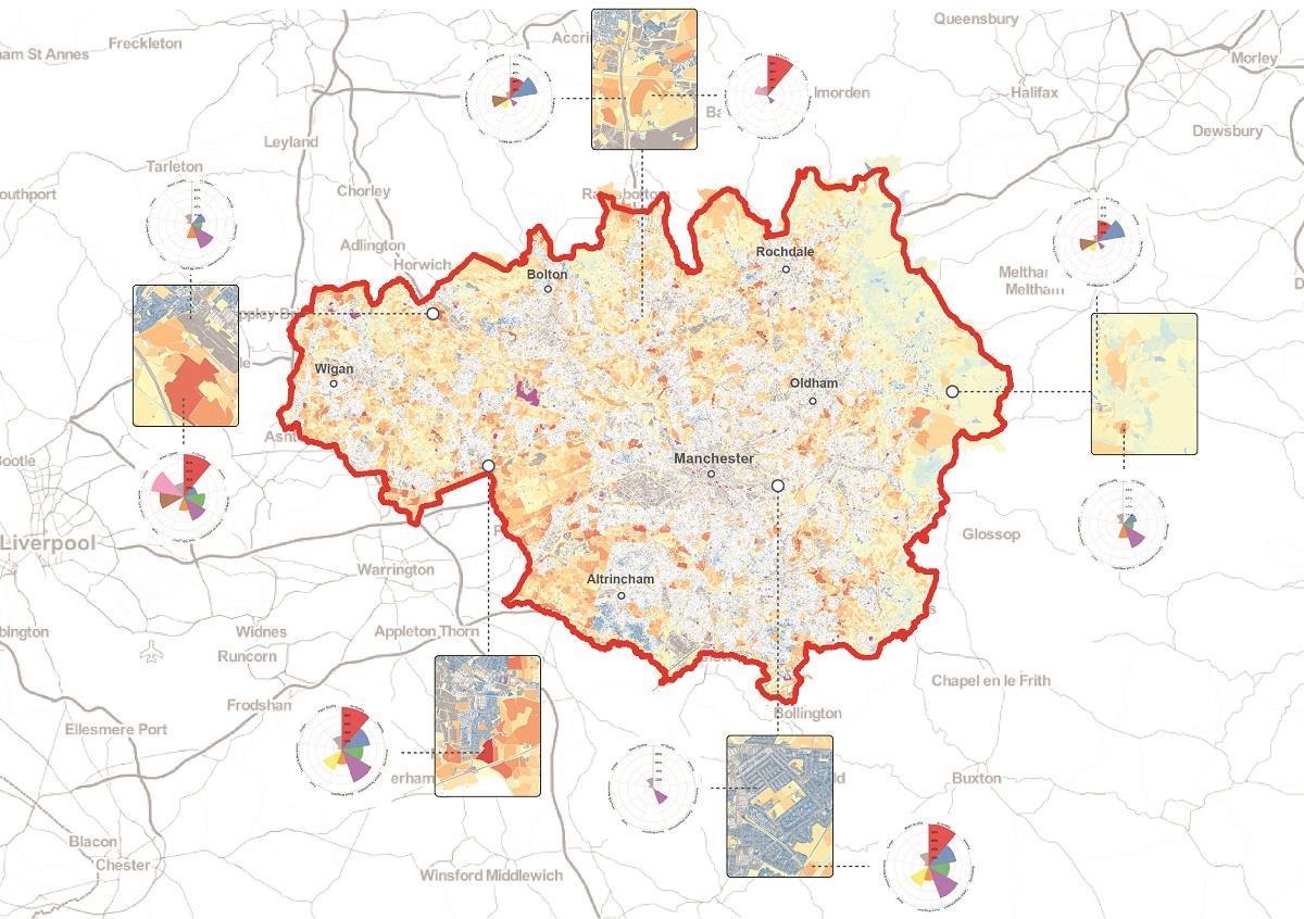
- Creation of an interactive ESS opportunity map, tested by end-users;
- Stakeholder engagement sessions;
- Training on how to use the map and authoring a user guide; and
- Identification of gaps in ESS provision and potential investment opportunities.
As landscape professionals, we aim to shape better environments for the next generation. In the UK, the most challenging arena is the post-industrial landscape where there are intense development pressures in landscapes needing restoration. Our project highlights where and how ESS can be enhanced alongside river restoration and economic development projects in and around Greater Manchester.
The project shows that landscape managers and scientists can create a landscape-scale ESS assessment of value to decision makers and land managers. Collectively, the landscape professionals created a framework to identify and communicate opportunities for Green Infrastructure improvements that would increase the flow of ESS.
GMCA used the evidence from the project to improve its own understanding of the scale and value of ESS provided by the IMC and, subsequently, to approach stakeholders and promote investment in the natural environment. Natural capital, with its emphasis on nature as an investible asset, has been gaining traction in UK and international policy, with growing recognition that if economic growth is to be sustained, natural capital has to be safeguarded. The government’s 25-year plan for the environment recognises river catchments as building blocks for long term protection and enhancement of natural capital. The project enables policy-makers and funders to invest in improvements to river valleys in Greater Manchester, ranging from small scale enhancements to large ambitious proposals.
The scale of IMC was huge and technically challenging, requiring use of cloud computing power to enable several different ESS opportunities to be measured and mapped. LIDAR was used to construct a detailed land surface model which enabled TEP to map surface water flow paths, and calculate surface wetness and slope indices at a very fine-grain. The interactive and intuitively designed web mapping output enables a wide range of users to access and integrate the data for their own uses and avoid pdf or hard copy plans. Pre-existing ESS opportunity maps focussed on rural catchments, so we developed assessment criteria appropriate to inner-urban and fringe landscapes.
A map user training programme is provided on MappingGM.
This project demonstrates that providing a better understanding of the significant monetary value of the ESS that are provided by waterbodies can help direct investment to areas that need it the most. The innovative methodology is wholly replicable and could be used across different landscapes and varying scales. The project sets a precedent whereby GMCA and their stakeholders have a robust evidence base which can be interrogated on the MappingGM web tool so that the legacy of the project continues.
Overview
-
Project Name
Charting a Natural Course: An Ecosystem Services Opportunities Map and Natural Capital Account for the River Irwell
-
Location
Greater Manchester
-
Category
Research, documentation and publication
-
Landscape Architect
The Environment Partnership (TEP) Ltd
-
Client
Greater Manchester Combined Authority (GMCA)
-
Brief
The project requirements were to: - Produce an ecosystem services opportunity assessment for watercourses in the Irwell Management Catchment; - Provide an evidence base to promote investment in, and delivery of, opportunities to protect and enhance the natural capital of the Irwell’s watercourses; and - Create a broader understanding of actions that could be taken to improve the flow of ecosystem services.
-
Awards
Finalist, Landscape Institute Awards 2019
Details
-
Project Team
Client: Krista Patrick (Greater Manchester Combined Authority (GMCA)) Project Team: Mike Hodgkinson CMLI (TEP), Francis Hesketh CMLI (TEP), Andy Harney (TEP), Alice Kennedy CMLI (TEP), Rebecca Martin CMLI (TEP), Joe O'Reilly (TEP), Robin Smale (Vivid Economics) and Ashley Gorst (Vivid Economics).
-
Year Completed
2019
-
Project Size
120,000 ha
-
Contract Value
£46,000
-

The Environment Partnership (TEP) Ltd
Registered Practice - (21 + Employees) -
Approximate Map Location

Location
Greater Manchester
-
Share


