
As an evidence-based speciality and discipline, landscape architecture needs a sound scientific basis to evaluate the current situation of the landscape and to guide future sustainable development. Recently, the concept of performance has been introduced into landscape architecture, which is defined as "the measurement of the efficiency of landscape solutions in achieving their intended objectives while satisfying sustainability".
The study of landscape performance is significant to landscape architecture. It can support the sustainable development of landscape practice. Also, it is one important way for landscape architecture to shift from experience to scientific research. In the past 20 years, countries like the US have launched performance evaluation systems for buildings, settlements and the environment, such as LEED (1999), SITES (2006), and LPS (2010). These systems provide a framework for the performance evaluation method. However, limitations still exist in the comprehensiveness of the index type, the integrity of the computational model, and the focus on the completion. In China, performance evaluation guidelines for large-scale eco-city construction (2015) have been made, but it does not consider the specific impact of small-scale factors on ecological construction. The actual promotion of LPES in China is still in its infancy.
Beijing, as the capital of China and a developed metropolis, has a large scale and high level in landscape architecture. After decades of development, Beijing's urban green spaces have significant differences in scale, type and construction age, and the quality is uneven. Therefore, measurement standards and construction guidelines are urgently needed for the sustainable development of green spaces. Meanwhile, quantitative performance evaluation and a practical design and construction feedback mechanism are also required to promote the development of green open space. It is highly necessary for Beijing to establish a comprehensive LPES to take the lead in promoting quantitative performance assessment in landscape architecture in developing countries.
Research objectives: quantitative evaluation toolset + open public participation platform
1. Construct a set of indicator calculation tools covering ecological, social and economic aspects to form a guiding and exemplary LPES.
2. Develop an online performance evaluation platform that achieves multi-directional interaction, long-term cooperation and timely feedback between the public, stakeholders and researchers to promote the standardized and refined development of the landscape industry.
The research covers four stages.
1. Beijing landscape spatial data collection and indicator extraction
2. Construction of LPES indicators set
3. Establishment of an online LPES platform
4. Performance evaluation and verification of offline sites for typical green open spaces
The four stages support and feedback to each other. Meanwhile, researchers, stakeholders and public participation during the research period to promote research sustainability and optimization.
In the research, the team has achieved the following results:
1. A set of calculating tools covering ecological, social and economic indicators of landscape performance
2. A study report on LPES
3. A computer software copyright registration certificate
4. A public open LPES platform with built-in quantitative parameter calculation tools (http://lap.bjfu.edu.cn/perform/index.html).
Under the help of the LPES, the team has evaluated green spaces such as micro-green spaces, urban parks, plazas and forest parks, completed dozens of reports, provided services to dozens of pre- and post-evaluations of projects and evidence-based design for more than twelve institutions. The Qinglong Lake case conducted by the team can fully reflect the guiding role of LPES.
Enhance the Multiple Value of Green Infrastructure through LPES: a Case Study of the Qinglong Lake Area
The Qinglong Lake area, located in the hillside area of Beijing and with an area of 4.5 km2, controls the small watershed of 102 square kilometres upstream. It undertakes the agricultural and water supply functions in the surrounding area. Based on its natural resources, the region has developed economic industries related to agriculture, mining collection and tourism development, which have brought economic income to the surrounding 32 villages. However, these economic developments have caused ecological degradation, which has limited the development prospects of this region.
Under the guidance of Beijing's hillside ecological protection planning, the Qinglong Lake area began to implement ecological restoration of its forest land of 1,343 hectares in 2012. As an essential ecological node of the hillside, in addition to forest replanting, a green infrastructure with complex functions is also established in the region:
1. Restore biodiversity of local plant communities;
2. Improve water conservation capacity of regional vegetation;
3. Restore the regional forest landscape and improve the scenic beauty of the area.
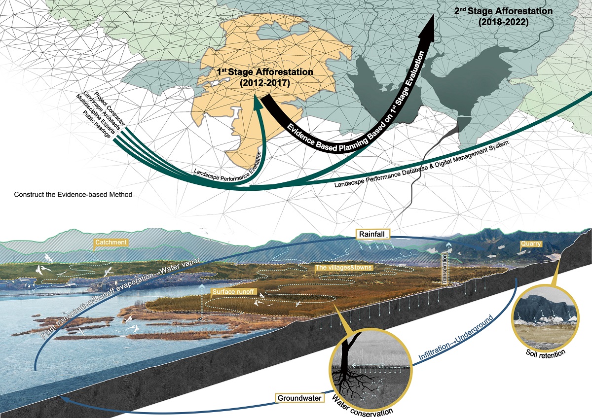
The first stage of the project, which began in 2012 and covers an area of 487 hectares, mainly concentrates on afforestation in the hillside of adjacent towns. Six teams with different backgrounds intervened and guided the generation and implementation of the 1st stage — however, a precise assessment method to measure the effectiveness not achieved. Therefore, the Qinglonghu Town Government invited the research team to apply the developed LPES to conduct an overall assessment of the first-stage restoration and to develop a strategy for the second stage.
In 2018, the research team started from the three goals and selected 29 factors in the LPES involving habitat, water and scenic beauty. Based on the LPES, the team verified the success and deficiency of various natural and artificial elements in the site in ecological condition and spatial structure by data acquisition, simulation calculation and laboratory analysis of relevant factors.
Typical evaluation methods include:
1. Biodiversity assessment: The INVEST model was used to analyze habitat quality. Based on the feature points of habitat quality, a sample survey was conducted to calculate the Shannon Biodiversity Index. According to the survey, the spatial analysis of the combination and richness of arbour, shrub and grass in the multi-layer planting was carried out in order to figure out how to improve biodiversity with different planting strategies.
2. Evaluation of water conservation capacity: DEM data was used to simulate surface runoff. By combining with the vertical structural characteristics of the community, water samples at typical sampling locations were collected in order to measure the number of TSS and COD in water. Through analysis, the filtering and purification of surface runoff by different vertical community combinations can be reflected.
2. Evaluation of scenic beauty: the sampling parties were selected with three main viewing lines: mountain, water and plant communities; the scenic beauty of the samples was valued according to the method of scenic beauty evaluation(SBE). Finally, plant communities with high scenic beauty were mapped and summarized.
The results of LPES can directly reflect the ecological and social performance level of different spaces in the 1st stage project and the corresponding planting patterns of various plants. By summarizing the high-performance model, the team proposed three guidelines for the completed 1st stage and the future 2nd stage of the 856 hectares.
1.Determine the future vertical community structure model according to the current situation and enhance species richness of forest habitat.
2. Implement planting strategies based on topography, realize the objectives of preventing soil erosion on high and steep slopes, regulating and storing runoff, purifying terminal runoff, and construct a multi-level water conservation system.
3. Promote the protection, upgrading and renewal of forest landscape by zoning landscapes according to human activities.
Based on conditions of the 2nd stage, the team mapped the above three guidelines for spatial planning and implemented them in 2019. The research team will perform periodical track and evaluation towards the landscape performance of the site over a long period to provide supports for the full-lifecycle management of the green infrastructure, and also improve the evaluation process of the relevant indicators in the LPES with dynamically updated data feedback.
Through the evaluation of LPES and the feedbacks by the applicants, the benefits of promoting the project can be listed as follows.
1. Improve the sustainable quality of landscape projects: The combination of design, construction and online service platform provides the basis for the pre-design decision-making and the after-design maintenance and update basis, which will effectively improve the quality and efficiency of a project.
2. Promote the progress of landscape industry: the online system can collect the evaluation results of multi-type projects in the same region, forming a growing database. Also, it promotes the improvement of design level, construction quality and quantitative management, which will form a landscape design system with the full life cycle.
3. Create more significant social benefits than similar technologies: The LPES quantifies and visualizes the project indicators, strengthens communication and maximizes the needs of various stakeholders throughout the landscape design cycle.
In general, LPES, which has essential promotion prospect, will push the industry into a new era of evidence-based design.
Overview
-
Project Name
LPES as a Guide to Evidence-based Green Infrastructure Planning: a Case Study of Qinglong Lake Forest Restoration Planning
-
Location
Qinglong Lake, Beijing, China
-
Category
Research, documentation and publication
-
Landscape Architect
Beijing Forestry University
-
Client
Beijing Municipal Science and Technology Commission
-
Brief
As an evidence-based speciality and discipline, landscape architecture needs sufficient and sound scientific basis to evaluate the current situation of the landscape and to guide future sustainable development. Recently, the concept of performance has been introduced into the research and practice of landscape architecture, which is defined as "the measurement of the efficiency of landscape solutions in achieving their intended objectives while satisfying sustainability". By taking Qinglong Lake as a case study, this project aims to explore an evidence-based design method of ecological green infrastructure based on the performance evaluation system and to develop and apply landscape performance evaluation in the whole cycle of ecological restoration planning. Firstly, a phased overall assessment is carried out against the first-phase ecological restoration results. Then, strategic and guiding strategies are provided against the second phase of ecological restoration planning based on the three design goals — community biodiversity restoration, water conservation and improvement of soil and water conservation capacity, and scenic recreation value evaluation. In the course of above concrete practice and based on the comprehensive positive benefits, we have found the application potential and promotion prospects of the project. Under the influence of evidence-based thinking, it not only enhances the sustainable quality of landscape projects and all-round participation of the landscape industry in the whole cycle but also produces social benefits for all members of the public.
-
Awards
Finalist, Landscape Institute Awards 2019
Details
-
Project Team
Research project team: ZHENG Xi, LI Xiong, WANG Xin, YAN Shuyi, LIU Zhe, WANG Jing, OU Xiaoyang, Cai Yiran, AI Xin, LI Jiayi, LIANG Shuyu, LIU Yang, School of Landscape Architecture, Beijing Forestry University
-
Year Completed
2019
-
Project Size
450 ha
-

Beijing Forestry University
-
Approximate Map Location

Location
Qinglong Lake, Beijing, China
-
Share


